Labels on Layers
You can choose to display labels on your map to help
with identification of the various parts. Typically the labels could
be the name of the country or continent, the abbreviation usually
used for a given country, the name of a road or installation, and
so on. A list of label types is proposed (if available) when you select
the
Labeling property of a layer in the
Map Style Property Sheet. The label types for a given layer are contained in the
map data and are reflected in the list. When you add labels to a layer
for the first time, a Labels layer is created in the Map Layers pane.
The following figure shows an example of a map with NAME
labels for countries.
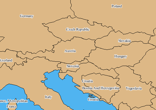
Labels
For more information, see Displaying labels.
Labels on Sublayers
Labels sublayers give you the possibility to label each
vector layer differently. For example, the labels can be:
- Centered for areas and countries
- Along polylines for roads
In addition, it is important to distinguish the visible
differences between road, motorway, and state or county labels to
make the map more readable. You can do this by setting the font size,
fill color, whether the outline is drawn, and if so what the outline
color will be. See Using the map style property sheet and Setting sublayer properties for
more information on how to use the Property Sheet.
Each time you set the
Labeling property
for a displayed data source containing label information, a Labels for: sublayer is created in
the Map Layers pane under the Labels layer. You can then specify the
style of labeling for each Labels sublayer using the corresponding
Property Sheet. The order of the Labels sublayers in the hierarchy defines
the priority of the labeling. When the labeling is performed, the
labeler places as many labels as possible on the first layer in the
hierarchy, and then considers the placement of labels on the next
Labels sublayer, and so on.
You can then specify the priority of the labeling by
reordering the Labels sublayers. This enables you to distinguish between
the labeling layers more easily and prevent the view becoming too
complex. Note that the layer with the highest priority is situated
at the bottom of the stack.
The following figure shows an example of customized Labels
sublayers.

Customized Labels sublayers
For more information, see Displaying labels.