An annotation is a drawing made on the top of a map to
describe or provide additional information about a specific zone of
a map. Annotations are labeled and are projected with respect to the
coordinate system of the map. Labels can be created to provide text
information and are displayed using the JViews Maps labeling mechanism,
(see Editing annotation labels).
You can also add a description to an annotation that can be multiline,
formatted using HTML tags, and displayed as a tooltip when the mouse
is held over the annotation.
You can use map annotations to add, for example, specific
points, borders, sections, divisions, limits, or areas of interest
to your map, (see Creating annotations).
There are several types of annotation that you can add:
- Points
- Polylines
- Polygons
- Links
Each time you create a point, polyline, polygon or link,
it is added to the annotations layer in the Map Layers pane.
You can customize the annotations in a number of ways
and can also carry out management operations on them. For example,
you can change the line width, change the fill color, modify the label,
and make the annotation visible or invisible. In the case of polylines
and polygons, you can add or remove a point to or from the annotation
and drag a point to another position to change the shape.
The following figure shows an example of annotations
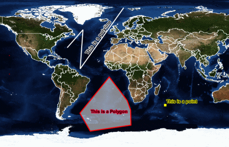
Adding Annotations to a Map
For more information about annotations, how to manage
them, and how to set their properties, see Managing annotations.