Grid settings enable you to choose between having no grid displayed
on the map or having a Military Grid Reference System (MGRS) or a
latitude/longitude grid displayed. The grid settings are displayed
in a pane in the Map Builder under the Grid
Settings tab. You can select the grid type from a list.
The following figure shows a Grid Settings
pane.
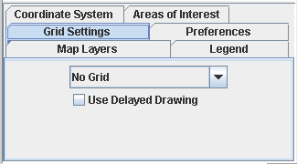
Grid Settings pane
When the Use Delayed Drawing option is
selected, there is no full drawing of the grid when the map changes
or moves, for example, when you use the zoom control in the
Overview pane or pan the map. Full drawing of the grid only occurs
when there is no movement or change to the map. This avoids
unnecessary grid drawing, which results in improved performance and
response time.
When you add a grid to a layer a Grid layer is also created, which
enables you to set the corresponding properties (colors, fonts, and
so on). See Using the map style property sheet for more
information.
The following figure shows an example of a
Latitude\Longitude grid.
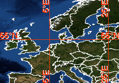
Grid display
For more information, see Displaying
a grid.