
Rogue Wave Views 5.6
Rogue Wave Views
Maps Package API Reference Guide
Rogue Wave Views
Documentation Home
Rogue Wave Views 5.6 |
Rogue Wave Views |
Rogue Wave Views Documentation Home |
This class defines the Geographic projection. More...
#include <ilviews/maps/projection/geogproj.h>
Public Member Functions | |
| IlvGeographicProjection () | |
| Constructor. | |
| virtual IlvProjection * | copy () const |
| Returns a copy of the projection. It must be overridden in each subclass. | |
| virtual IlvProjectionClassInfo * | getClassInfo () const |
| Returns the class information for the projection. | |
| virtual IlvMapsError | setEllipsoid (const IlvEllipsoid &ellipsoid) |
| Sets the ellipsoid used for the projection. | |
Static Public Member Functions | |
| static IlvProjectionClassInfo * | ClassInfo () |
| Returns the class information of the class. | |
| static IlvClassInfo ** | ClassInfoRef () |
| Returns the address of the class information of the class. | |
Protected Member Functions | |
| virtual IL_STDPREF ostream & | printPROJ4Descriptor (IL_STDPREF ostream &, IlvMapsError *status=0) const |
| This virtual member function converts the projection to a string in the PROJ4 format. | |
| virtual IlvMapsError | sForward (IlvCoordinate &ll) const |
| Must be redefined in subclasses to implement the projection for a sphere. | |
| virtual IlvMapsError | sInverse (IlvCoordinate &xy) const |
| Must be redefined in subclasses to implement the inverse projection for a sphere. | |
This class defines the Geographic projection.
It outputs the latitude and longitude in degrees. The unit converter of the projection is initialized by the projection to convert degrees into meters at the equator.
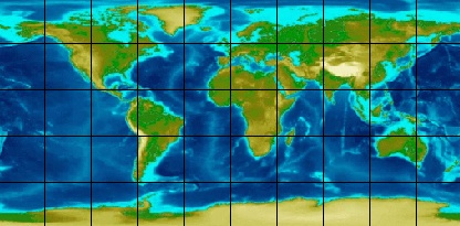
Geographic Projection
Library: ilvmaps
| IlvGeographicProjection::IlvGeographicProjection | ( | ) |
Constructor.
Initializes an instance of the class IlvGeographicProjection.
| static IlvProjectionClassInfo* IlvGeographicProjection::ClassInfo | ( | ) | [static] |
Returns the class information of the class.
This static function is also available for the subclasses of IlvProjection.
IlvProjectionClassInfo of the class. Reimplemented from IlvProjection.
| static IlvClassInfo** IlvGeographicProjection::ClassInfoRef | ( | ) | [static] |
Returns the address of the class information of the class.
This static function is also available for the subclasses of IlvProjection.
IlvProjectionClassInfo of the class. Reimplemented from IlvProjection.
| virtual IlvProjection* IlvGeographicProjection::copy | ( | ) | const [virtual] |
Returns a copy of the projection. It must be overridden in each subclass.
Implements IlvProjection.
| virtual IlvProjectionClassInfo* IlvGeographicProjection::getClassInfo | ( | ) | const [virtual] |
Returns the class information for the projection.
Reimplemented from IlvProjection.
| virtual IL_STDPREF ostream& IlvGeographicProjection::printPROJ4Descriptor | ( | IL_STDPREF ostream & | , | |
| IlvMapsError * | status = 0 | |||
| ) | const [protected, virtual] |
This virtual member function converts the projection to a string in the PROJ4 format.
| ostream | The output stream receiving the string. | |
| status | IlvMapsError reporting a write error. |
Reimplemented from IlvProjection.
| virtual IlvMapsError IlvGeographicProjection::setEllipsoid | ( | const IlvEllipsoid & | ellipsoid | ) | [virtual] |
Sets the ellipsoid used for the projection.
This virtual member function sets the ellipsoid used for the projection. Most of the projections are initialized with a spherical ellipsoid with a radius of 6,370,997 meters.
This function returns IlvMaps::NoError() if the operation is successful or an error status if you specify a non spherical ellipsoid and your type does not support non spherical.
| ellipsoid | The ellipsoid used for the projection. |
IlvMapsError if the ellipsoid does not match the projection. Reimplemented from IlvProjection.
| virtual IlvMapsError IlvGeographicProjection::sForward | ( | IlvCoordinate & | ll | ) | const [protected, virtual] |
Must be redefined in subclasses to implement the projection for a sphere.
| ll | Contains the longitude and latitude coordinates in radian (x = longitude, y = latitude). |
Implements IlvProjection.
| virtual IlvMapsError IlvGeographicProjection::sInverse | ( | IlvCoordinate & | xy | ) | const [protected, virtual] |
Must be redefined in subclasses to implement the inverse projection for a sphere.
The default implementation returns IlvProjection::UnsupportedFeatureError().
| xy | Contains the Cartesian coordinates to inverse. |
Reimplemented from IlvProjection.
© Copyright 2012, Rogue Wave Software, Inc. All Rights Reserved.
Rogue Wave is a registered trademark of Rogue Wave Software, Inc. in the United States and other countries. All other trademarks are the property of their respective owners.

