Setting the number of calibration points
Calibration in the Image Calibration pane uses an IlvFittedTransform class. This class
requires a certain number of points to be entered for more
complex transformations (that is, a higher degree of
interpolation).
You must enter:
- For a degree 1 polynomial (linear transformation): 3 calibration points.
- For a degree 2 polynomial transformation: 6 calibration points.
- For a degree 3 polynomial transformation: 10 calibration points.
- For a degree 4 polynomial transformation: 15 calibration points.
Polynomial interpolations are more
precise in the area inside the calibration points. If you use
this feature, try providing calibration points that cover as
large an area as possible.
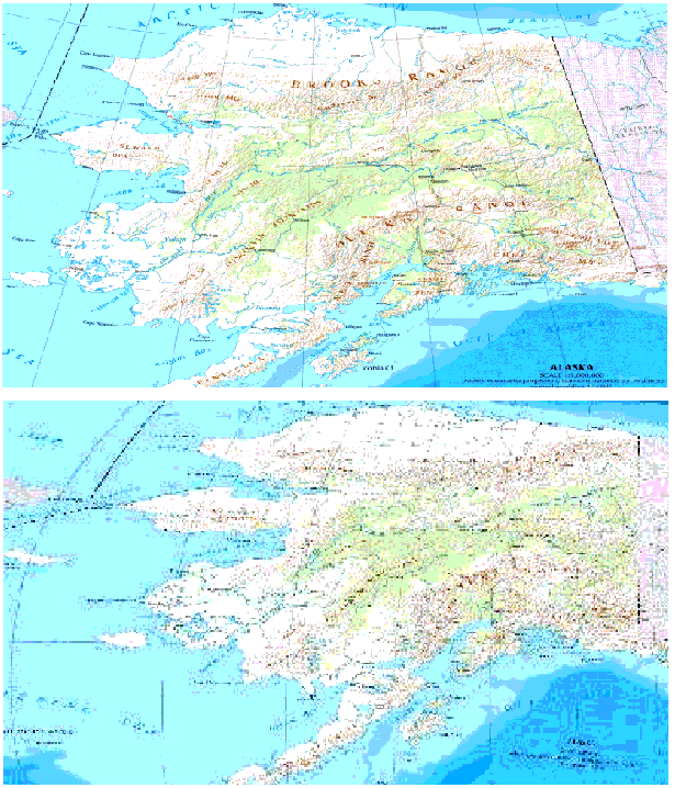
The first part of the following figure
shows an initial map of Alaska. Calibration points have been
placed around the right side of this image. The second part of
the following figure shows the interpolated image, however, the
left side is quite skewed.
Setting calibration points
Predefining the Image Bounds Using World Files
World files provide information for image calibration. A World
file has the same filename as the main image file. For example,
a file called
USA.jgw
could accompany an image named
USA.jpg
, and contain the coordinates of the image in seconds of arc.
An example of a World file content is as
follows:
1.50000000000000 (X pixel size)
0.00000000000000 (translation)
0.00000000000000 (rotation)
-1.50000000000000 (Y pixel size)
1934001.50000000000000 (X coordinate of the upper left pixel)
1187698.50000000000000 (Y coordinate of the upper left pixel)
The Map Builder ignores the translation
and rotation parameters.
When loading images in GIF, JPG, PNG, or
TIF format, the Map Builder scans the directory to see if a
World file exists, and if so, predefines the image bounds
accordingly in the importation dialog box.
For GIF, JPG, PNG, and TIF formats, the world file extensions
checked are in the form
.tifw
or
.tfw
,
.gifw
or
.gfw
,
.jpgw
or
.jgw
, and
.pngw
or
.pgw
respectively.