Spatial Reference Systems (SRS) are a way to link coordinates
to a reference, so that objects whose coordinates are expressed in
different systems can be displayed in the same manager.
JViews Maps features, or generally speaking graphic
objects on maps, are representation of real objects. These map features
have to be linked to real-life objects, and this is performed by attaching
the attributes to the map features. These attributes can be a location,
a time, or any descriptive quality or quantity. For example, you can
describe the position of a restaurant either using its coordinates
(The restaurant coordinates are 2D28’30’’E, 48D59’05’’N),
or a description (The restaurant is at the crossing of X and Y streets,
on the same walkway as the cafe). This link between objects and their
real life counterpart is called a reference
system.
Coordinate system base class
The JViews Maps supports Spatial Reference Systems where the reference attributes are coordinates.
The abstract class IlvCoordinateSystem serves as base class for all the coordinate systems.
An
IlvCoordinateSystem is
defined by:- A optional name.
- An array of
IlvUnitdefining the units to be used on each axis. - An array of
Stringdefining the name of each axis. - The dimension of the coordinates in use in the system are defined by the number of axes.
There are three major classes of coordinate systems useful
for mapping software:
- Geocentric Coordinate SystemRepresents coordinates in a three-axes Cartesian system, whose origin is the center of Earth. This coordinate system is mainly used in datum conversion.
- Geographic Coordinate SystemRepresents the coordinates specified by angles on an ellipsoid (longitude and latitude). An optional height above the ellipsoid can be used here. For example, this is the standard longitude and latitude given by GPS.
- Projected Coordinate SystemRepresents the coordinates of the Earth on a 2-D surface. There are as many projected coordinate systems as the number of existing projections. Projecting coordinates on a 2-D surface is mandatory to display data on a map. As the projection process introduces some errors, not all projections are well suited to represent an area on Earth. For more information, see Map projections.
Geocentric Coordinate System
The IlvGeocentricCoordinateSystem class defines a geocentric coordinate system, that
is, a three-dimensional Cartesian system. The origin point of this
Cartesian system is the center of the Earth.
The axes are perpendicular and defined as follows:
- the x-axis lies in the plane containing the equator, and has positive values towards the Greenwich meridian
- the y-axis lies also in the plane containing the equator, and is positive towards the longitude 90 degrees east of Greenwich
- the z-axis corresponds to the polar axis, and is positive northwards
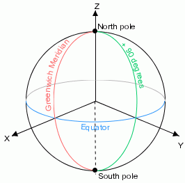
The geocentric coordinate system
Coordinates in a geocentric coordinate system are expressed
in linear units along the axis.
The geocentric coordinate system is mostly used as the
base reference system from which geographic and projected coordinates
are derived. For example, geodetic datums (horizontal datum) are defined
by the shift, rotate and scaling parameters to convert a geocentric
coordinate system to a reference geocentric coordinate system (in
most cases, the WGS84 datum).
Geographic Coordinate System
The IlvGeographicCoordinateSystem class defines an ellipsoidal coordinate system where
coordinates are specified as latitude and longitude on an ellipsoid,
with an optional third coordinate which represents the ellipsoidal
height (altitude above the ellipsoid).
- Longitude is specified in angular units from the prime meridian of the coordinate system. By convention, coordinates less than 180 degrees east of the prime meridian are positive, coordinates more than -180 degrees west are negative.
- Latitude is specified in angular units from the equator. By convention, northward latitudes are positive and southward coordinates are negative.
- The convention for representing the poles are longitude set to 0 and latitude set to 90 degrees for the north pole or -90 degrees for the south pole.
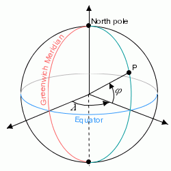
The geographic coordinate system
Projected Coordinate System
The geographic and geocentric coordinate systems are
not well suited to display maps, since these coordinate systems define
map features in a three dimensional world. Before displaying objects,
the dimension of coordinates must be reduced to 2. This is performed
using map projections (see Map projections).
A projected coordinate system includes all the parameters
that allow you to describe a coordinate system in which each planar
coordinate is computed from geographic coordinates using a mathematical
function. These include:
- The reference geographic coordinate system (the surface modeling the Earth).
- The mathematical transformation itself (the projection).