Preferences enable you to set distances, altitudes, and
coordinates in the units of your choice. The preferences are displayed
in a pane in the Map Builder under the Preferences tab. You can change preference
settings at anytime and the changes take place immediately. The preference
settings can affect, for example, the units of the altitude charts
used in terrain analysis, the orthodromy measures drawn on the map,
the scale bar, and mouse locator units.
You can select the units from a list in the preferences
tab, as shown in the following figure.
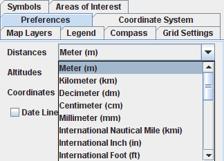
Preferences pane
The Date Line Wrapping option
can be used to cut polygons that circumnavigate the world. Note that
this option is only applied when the next reprojection occurs, for
example, when you change the center of the projection.
For more information, see Setting preferences.