Real object coordinates can be expressed in
different systems. The main systems are:
Geographic coordinate system
In a geographic coordinate system,
latitude and longitude are used and are represented by two angles
from the center of the earth:
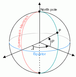
- Latitude = south to north +90 or 90N = north pole, -90 or 90S = south pole, and 0 is on the equator.
- Longitude = east to west. 0 is in England.
An example of coordinates using the geographic: longitude and
latitude with optional altitude is shown in Geographic coordinate system.
Geographic coordinate system
In a geographic coordinate system the
angular distance is expressed in degrees and minutes, for
example, New York:
- Latitude 40 Degrees 59'N
- Longitude 73 Degrees 39'W
A geographic coordinate system is defined
by:
- The unit system of coordinates (angular unit and linear unit).
- The prime meridian:
- For example, the Greenwich meridian.
- The horizontal datum:
- A horizontal datum is used to represent the shape of the earth.
- The datum is defined by an ellipsoid (the default is a sphere) and a translation of the ellipsoid (position of the ellipsoid relative to the center of the earth), see Horizontal Datum:
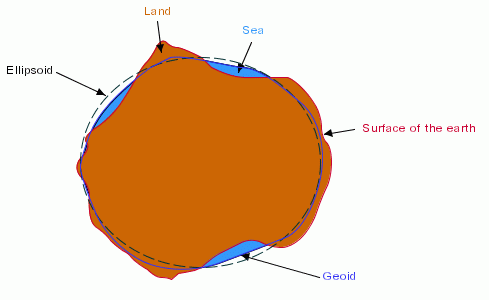
Horizontal Datum
Geocentric coordinate system
An example of coordinates using the geocentric: three-axis
Cartesian system with the center of the earth as the origin is
shown in Geocentric Coordinate System:
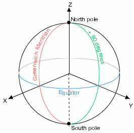
Geocentric Coordinate System
A three-axis Cartesian system is defined
by:
- Its origin, the center of the earth.
- Its x-axis, which lies in the plane containing the equator and which is oriented towards the Greenwich meridian.
- Its y-axis, which lies in the plane containing the equator and which is oriented towards the longitude 90 Degrees East of Greenwich.
- Its z-axis, which corresponds to the polar axis and which is oriented northwards.
A geocentric coordinate system is defined
by:
- The unit system of coordinates (linear units) on the axes.
- The horizontal datum.
Projected coordinate system
A projected coordinate system is a
representation of the earth on a 2-D surface. Units are attached
to each axis of a coordinate system. For example, for geographic
coordinates:
- x- and y-coordinates expressed in degrees
- z-coordinate expressed in meters
A kernel unit is defined for each type of
unit.
- Length in meters
- Angles in radians
Coordinate systems are used to display
maps and a map projection is used to reduce the dimensions to
two. A projected coordinate system is defined by:
- The associated geographic coordinate system
- The projection
- The unit system of projected coordinates