Once coordinate systems are defined, there must be some way to
convert from one coordinate system to another. This is done using
coordinate transformations, defined in the package ilog.views.maps.srs.coordtrans.
Overview of the coordinate transformations
As soon as you work with different
coordinate systems and datums, you need to be able to convert
from one to another. When working with coordinate systems, this
can be performed using functions.
The coordinate transformations, as defined by the ilog.views.maps.srs.coordtrans. IlvCoordinateTransformation class, contain
the information that allows you to manipulate them:
- The source coordinate system
- The target coordinate system
- The Math Transform to convert coordinates from one to another
In addition to that, all the coordinate
transformations implement the following methods:
IlvCoordinatetransformThis method is the basic one. It transforms the source coordinate, storing the result inresult, or in a newly allocated coordinate ifresultisnull. The method returns the transformed point.- IlvCoordinate[] transformThis is the vectorized version of the previous method. This allows the transformations to convert a whole batch of coordinates, possibly allowing some optimizations to be performed.
- Optionally, transformations can implement the getInverse method that returns an inverse transformation.
The following sections describe the predefined built in
transformations of JViews
Maps, and provide some examples of the transformation package.
Transformation paths
To transform the coordinates from one coordinate system to
another, mathematical functions are needed. These mathematical
functions can be either simple straight forward functions, or
more complicated transformations. The JViews Maps package
includes the most elementary transformations (or transformation
steps) used for coordinate conversions, and these are available
in the ilog.views.maps.srs.coordtrans package.
The chaining of elementary transformations from one coordinate
system to another is called a transformation
path.
The static method CreateTransformation from the class
IlvCoordinateTransformation
can automatically create transformation paths from coordinate
systems of the ilog.views.maps.srs.coordsys package. To
find the transformation paths created, refer to the following
figure:
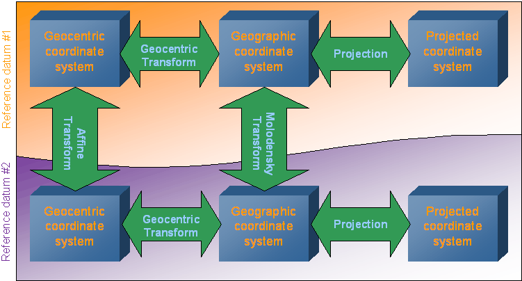
Transformation paths
Example
Convert from the following projected
coordinate system:
- Projection: Lambert Azimuthal Conformal Conic
- Datum: NTF (Nouvelle Triangulation de la France)
- Associated geographic coordinate system based on Clark 1880 ellipsoid, IGN modified.
to the following one:
- Projection: Mercator
- Datum: European 1960
- Associated geographic coordinate system: International.
The transformation path selected by
CreateTransformation()
will be:
- Projection transformation from Lambert to geographic NTF/Clark1880
- Molodensky conversion from NTF/Clark1880 to European 1960/International systems
- Projection transformation from geographic European 1960/International to Mercator.
At each step, the relevant unit conversion is added by using the
affine transforms.
Note that this path is not the only
existing path. It is also possible to convert from geographic
coordinates to geocentric coordinates, in which case the
transformation path would be:
- Projection transformation from Lambert to geographic NTF/Clark1880
- Geocentric transform to geocentric NTF coordinates
- Affine transform to convert from NTF to European 1960 coordinates
- Geocentric transform from European 1960 to geographic coordinates
- Projection transformation from geographic European 1960/International to Mercator.