Class diagram
The class diagram for the reader framework is shown in Reader Framework UML Diagram.
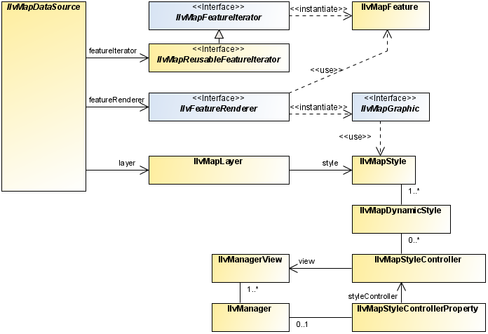
Reader Framework UML Diagram
JViews Maps provides
a set of classes that you can use to read data from various
cartographic data sources (files, databases, map servers, and so
on), create map features, transform the features into JViews Maps graphic
objects using renderers, and position them correctly onto an
existing map.
The IlvMapFeature class
The IlvMapFeature class in the package ilog.views.maps is the base class for map
features. This class allows you to read in data for cartographic
display from source files. A map feature can be, for example, a
segment of road, an aerial image, the summit of a hill, or a
digital terrain model. For more information about this class, see
Handling map features.
The IlvMapFeatureIterator interface
The IlvMapFeatureIterator interface in the
package
ilog.views.maps
is the common interface for readers. All the classes that
implement this interface can be used to read cartographic data,
whatever the original format. JViews Maps provides a
number of predefined readers, all of which, implement this
interface. These readers are described in detail in Readers and writers.
The IlvFeatureRenderer interface
The IlvFeatureRenderer interface in the package
ilog.views.maps
is the common interface for renderers. All the classes that
implement this interface can be used to translate an IlvMapFeature into a graphic object. JViews Maps provides a
default class ( IlvDefaultFeatureRenderer) implementing
this interface and being able to render most of the
IlvMapFeature
returned by the JViews
Maps predefined readers. A specific renderer can also be
provided by a reader (method
IlvMapFeatureIterator.getDefaultRenderer()
).
The IlvMapStyle class
The IlvMapStyleclass is a base class for the
style used with IlvMapGraphic graphic objects. A single
instance of IlvMapStyle can be shared by IlvMapGraphics that can read their graphic
(or other) attributes from the style.
The
IlvMapStyle
class should be used in conjunction with an IlvMapLayer. In this case, the
IlvMapLayer
applies the style to the objects within that layer. This can be
used to change the appearance of a layer dynamically without
reloading the map. Some attributes are layer specific, such as,
layer visibility, and layer transparency
The IlvMapGraphic interface
Graphic objects requiring that they read their graphic attributes
from a IlvMapStyle, must implement the IlvMapGraphic interface. Objects of this
class are rendered with IlvMapAreaRenderer, IlvMapPointRenderer, IlvMapCurveRenderer and IlvMapTextRenderer. These renderers are
used by the data sources provided by JViews Maps.
The IlvMapDynamicStyle class
The package package-frame contains classes used to
change dynamically the style of a layer when the scale changes.
The IlvMapDynamicStyle associates an IlvMapStyle and a scale, and is used with a
IlvMapStyleController. If the controller is
installed on the view of the map, it listens for changes to the
scale of the map and selects the appropriate style to apply to
the appropriate layer. This allows a map to have different
appearances at different scales.