A background map is typical of applications that require
georeferenced data, for example, vehicle routing or network
management. To use predefined maps supplied with JViews Diagrammer or to
create your own maps with Rogue Wave JViews Maps, you must have
purchased and installed the JViews Maps product. The JViews Map
Builder and JViews Maps API of JViews Maps allow you to create
maps for a specific region with features such as roads and
boundaries.
You can select a Map Diagram in the New
Diagram Wizard; see the following figure.
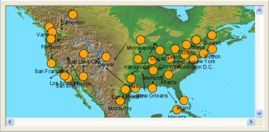
A diagram with a background map
To see this diagram, load the XML data file supplied as <installdir>/jviews-diagrammer810/bin/designer/data/examples/example.xml;
the New Diagram Wizard sets the Map Diagram type by default
because of the latitude and longitude values present in the data.
Note that users cannot interact with the
map: it is a static file.
If you do not select a Map Diagram in the
New Diagram Wizard, you can later add a map to an existing
diagram.
To add a background map:
-
Click Edit > Options.
-
Check the Background Map box.
-
Click OK.
The default map in the Designer is a world map. Your nodes are
positioned according to their latitude and longitude attributes.
If the data model does not include these
attributes, the nodes are positioned in the upper left corner of
the map.
To change the background map:
-
Select Background Map in the Options section of the Style Rules pane.
-
Set Map to the appropriate file name in the Styling Customizer.