Each map layer has a set of properties
associated with it. The properties define the characteristics of
the selected layer. Using the Map Style Property Sheet you can
customize the kind of map data selected (vector, raster, or
elevation), define whether the map outline is shown or not, what
colors are used to fill the terrestrial and marine areas, define
the transparency level, and so on. The Map Style Property Sheet
gives access to a number of editors that enable you to carry out
these operations.
For example, for the
Labeling
property, a choice of label types is displayed that depends on the
content of the data source. This enables you to display labels, for
example, as the name of the country, or at a more detailed level
such as the name of a street. You can change any property value at
any time. The properties defined for each map layer constitute a
layer style and each layer style contributes to the overall map
theme.
Note that some properties are not displayed in the Map Style
Property Sheet by default. To display all the properties you must
select Options>Show Advanced
Properties.
The following figure shows an example of a
Map Style Property Sheet.
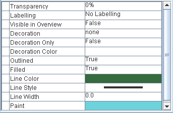
Map Style Property Sheet example