Projection Parameters
The following parameters can be set for a projection:

The ellipsoid that specifies the figure of the earth. Ellipsoids are discussed in the section
Ellipsoids.
The unit converter that specifies the measurement unit in which Cartesian coordinates should be expressed. Unit converters are discussed in the section
Using Unit Converters Directly.
The central meridian and the central parallel of the projection. These parameters can be set with the
setLLCenter function. Projections produce less distortion near their center.
The offset applied to the Cartesian coordinates, also called false easting and false northing. These parameters can be set with the function
setXYOffset.
You can also:
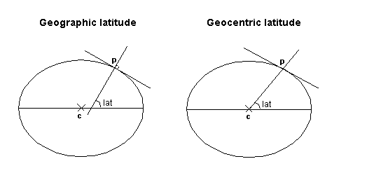
Specify whether the coordinates are geodetic (the default value) or geocentric using the
setGeocentric function.
The geocentric latitude of a point is defined by the angle formed by a line joining the point to the center of the earth and the equatorial plane, whereas the geodetic (or geographic) latitude of a point is defined by the angle formed by the vertical line passing through this point and the equatorial plane. The two values differ since the earth is not exactly a sphere but rather an ellipsoid. Both latitudes are related through the relation tan phiG = (1 - e ^ 2) tan phi where e is the eccentricity of the ellipsoid used to model the shape of the earth.
If an application handles geocentric data, this parameter must be set. Most of the cartographic data available is expressed with geographic latitudes.
Specify whether the projection uses longitude reduction, that is, forces longitude to be in the range
[-PI;PI], or accepts any longitude using the function
setUsingLongitudeReduction.
The above parameters are common to all the projections. They can be set with the API of the class
IlvProjection, which is the base class of all the projections in the library. Some projections have additional specific parameters. For example, secant latitudes can be specified for a conic projection, or the latitude of the true scale can be specified for most cylindrical projections. For more information, refer to the Reference Manual for each projection.
Version 5.8
Copyright © 2014, Rogue Wave Software, Inc. All Rights Reserved.