The Classes for Creating Maps: An Overview
Rogue Wave® Views Maps provides a set of classes that you can use to read data from various cartographic data sources (files, databases, map servers, and so on), create map features, transform the features into Rogue Wave Views graphic objects using renderers, and position them correctly onto an existing map.

The
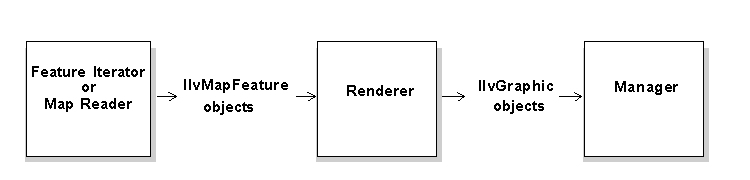
IlvMapFeature class is the item class for map features. A map feature is an object that represents a cartographic data as it was read from its source file. It can be a segment of road, an aerial image, the summit of a hill, or a digital terrain model. A map feature holds three main information fields:
geometry, the
projection in which its geometry is expressed, and its attributes. If the map feature is a town, for example, its attributes can be its name and the number of inhabitants. A map feature is completely independent of the way it will be graphically represented in the application. Thus, a point marking the summit of a hill might very well be represented with graphic objects as diverse as a cross, a circle, or an icon. For more information about this class, see the section
Feature Iterators.
The
IlvFeatureRenderer abstract class is used to transform map features into graphic objects that can be added to an
IlvManager. A feature renderer lets you select the graphic representation to be associated with a given map feature and to reproject its geometry in the projection system of the target application, if necessary.
The
IlvMapFeatureIterator abstract class is the common interface for readers. All the classes implementing this abstract class can be used to read cartographic data, whatever the original format. For more information about this interface, see the section
Feature Iterators. Rogue Wave Views Maps provides a number of predefined readers that all implement this interface. These readers are described in detail in
Chapter 5, Predefined Readers.
The following figure illustrates the process for loading cartographic data into Rogue Wave Views:
Figure 3.1 Loading External Cartographic Data into Rogue Wave Views
The
IlvMapLoader class in the package
format carries out this entire process automatically for all the predefined readers supplied with Rogue Wave Views Maps. For information about predefined readers, see
Chapter 5, Predefined Readers.
Version 5.8
Copyright © 2014, Rogue Wave Software, Inc. All Rights Reserved.