Perforce JViews Maps for Defense Sample: Custom Terrain Analysis
Description
 |
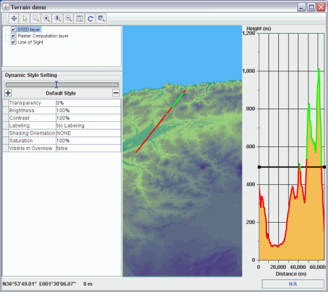
This sample shows how to use the terrain analysis API and overwrite standard algorithms.
How to Use the Sample
-
Line of sight: this line of sight has been changed to display its points as visible if the terrain
is above the altitude at which the line of sight starts.
The terrain cut chart is also changed to reflect this fact, by drawing a horizontal line.
You can change the altitude of the point of view in the layer styling sheet. -
Terrain analysis: the terrain analysis creates an image where each point has the altitude
multiplied by a ratio.
You can change the ratio in the layer styling sheet.
How to Run the Sample as an Application
This sample can
be run as an application.
The installation directory contains
an executable JAR file,
terrain.jar,
that allows you to execute the sample with a double click from a
file browser. Note that if you are using Internet Explorer, you can
open the installation directory
and execute the JAR file from the browser. This
technique may not work in other Web browsers.
Alternatively, you
can run the sample application from the command line.
First check that the Ant utility is properly configured. If not, see the
instructions on how to configure Ant for Perforce JViews.
Then, go to the installation directory
of the sample and type:
ant run
Topics Covered
- JViews Map API.
- DTED reader.
- Terrain Analysis.
Detailed Description
This sample shows how to use the terrain analysis API and overwrite standard algorithms.
Installation Directory
The Custom Terrain Analysis sample is installed here.
Classes Involved
- ilog.views.maps.IlvCoordinateSystemProperty
- ilog.views.maps.IlvMapLayerTreeProperty
- ilog.views.maps.beans.IlvJAutomaticScaleBar
- ilog.views.maps.beans.IlvJMouseCoordinateViewer
- ilog.views.maps.beans.IlvLayerTreePanel
- ilog.views.maps.beans.IlvMapLayer
- ilog.views.maps.beans.IlvMapLayerTreeModel
- ilog.views.maps.datasource.IlvMapDataSource
- ilog.views.maps.datasource.IlvMapDataSourceModel
- ilog.views.maps.datasource.IlvMapDataSourceProperty
- ilog.views.maps.format.dted.IlvRasterDTEDReader
- ilog.views.maps.raster.datasource.IlvRasterDataSourceFactory
- ilog.views.maps.srs.coordsys.IlvGeographicCoordinateSystem
- ilog.views.tiling.IlvFreeTile
- ilog.views.tiling.IlvTileController
- ilog.views.tiling.IlvTiledLayer