Before you start
Rogue Wave® JViews Maps for Defense offers a wide range of mapping services for building custom user interfaces.
To provide these services, it relies on services provided by JViews Diagrammer and JViews Maps.
To be successful with the JViews Maps for Defense product, it is important for you to understand its architecture and its dependencies.
If you are already familiar with Rogue Wave JViews Maps, here are the main additional features provided by Rogue Wave JViews Maps for Defense:

Terrain Analysis features
3D terrain views
Line of Sight
Area of Visibility
Gradient computations
High/low areas detection
Terrain cut along a polyline
MIL-STD 2525b/APP-6a symbology
Additional military map formats such as CADRG, DAFIF, VMAP, S57, ASRP, and USRP
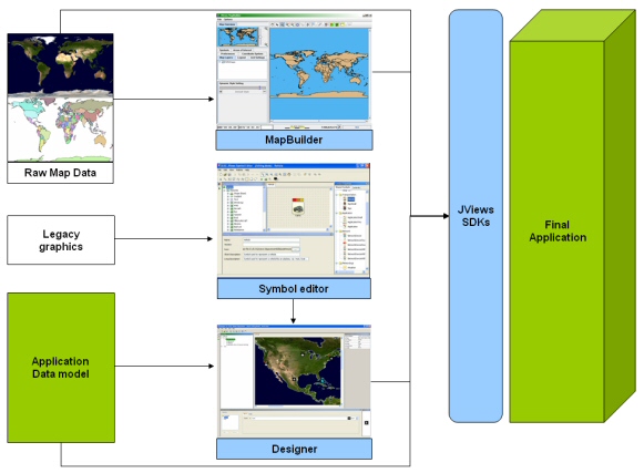
Rogue Wave JViews Maps for Defense is a collection of:
Applications
Software Development Kits (SDKs)
The applications are prebuilt and:
Preconfigure the maps used in the application during run time.
Define the symbols you can place on top of the maps and their behavior when application data changes.
NOTE
APP-6a Symbols are a specialized use of JViews Diagrammer capabilities. The coding of the APP-6a standard in a set of java classes provides even greater performance than the (more flexible) output of the Symbol Editor.
The applications are typically used to configure parts of your application before run time. They accelerate application development, but do not need to be used within your final delivery. The structure of Rogue Wave JViews Maps for Defense is shown below:
Rogue Wave JViews Maps for Defense structure
The features of Rogue Wave JViews Maps for Defense are also available through the SDKs, which provide a full range of features and greater flexibility. If necessary, you can extend the Java classes to create the precise user interface that your user requires.
Copyright © 2017, Rogue Wave Software, Inc. All Rights Reserved.